
-
Earth Science Journal!
Weathering and Erosion!
1. What's the difference between Weathering and Erosion?
Weathering: break up a rock
Erosion: move the pieces
Types of Weathering
2. Mechanical weathering:(disintegration)
smaller pieces, same stuff. Example: boulder → pebbles
3. Chemical weathering: (decomposition)
smaller pieces, changed stuff. Example: feldspar → clay
Types of Mechanical weathering
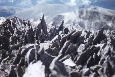
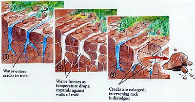
4. Ice wedging (Frost Action) Water seeps into small cracks and expands as it freezes, breaking the rock. Very strong force. ex: potholes, ice heaving. Ice Wedging is the main weathering force on mountain tops.
5. Abrasion: Rocks rub or collide against one another. ex: wind blown particles colliding, pebbles tumbling downstream, glaciers grinding rocks together.
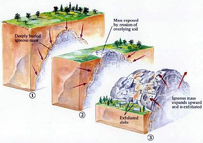
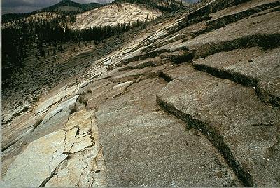
6. Exfoliation: (Pressure Release): breaking of rocks off mountains in large shells, creating rounded mountain peaks. When pressure is released rocks expand and crack, peeling off in sheets.
7. Plant and animal action: Plant roots expand in cracks of rock and break them apart. Animals burrow into the ground and expose the bedrock to air. Humans expose more rocks than any other animal.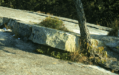
8. Humidity Changes: Wetting and drying rocks is very effective in breaking up rocks that contain clay. Clay expands when wet, breaking rocks like shale apart.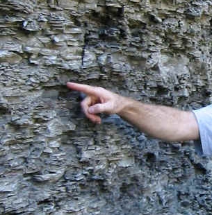 Jack and Trap Rock!9. Temperature Changes: Heating and cooling expand and contract the rock causing it to break. It is usually not strong enough to break rocks in nature unless they are in the desert.
Differential Weathering If a more resistant layer of rock is on top of a softer layer, you get weathering and erosion, undercutting the caprock.
10. Why is this big rock still held up in the air?
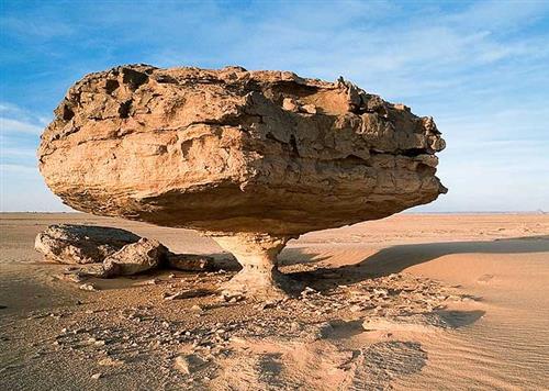
The blowing sand erodes rock closer to the ground because the wind does not carry larger sediment very high in the air.
Chemical weathering
11. Oxidation: Exposure to oxygen rusts the iron minerals in rocks and makes iron-oxide (rust) reddish rocks and soil. Red rocks and soil indicate oxidation. Oxygen, in the air we breathe, reacts with iron in minerals to form iron oxide minerals, e.g. hematite (rust). Many minerals contain iron, so it is not unusual to see red-colored rocks like the example shown here.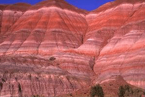
12. Hydrolysis: Some minerals (Feldspar, hornblende, and augite) form clay when exposed to water.
13. Carbonic Acid: Carbon dioxide from decaying organic material mixes with water, forming carbonated water. This water is slightly acidic and dissolves away minerals like calcite, changing the original mineral into a clay mineral. It produces caves and Karst topography.
Carbonic acid dissolves limestone as it filters down through the cracks in rock layers. When it reaches the caverns, the carbon dioxide escapes from the water and leaves some of the dissolved limestone in calcite first on the ceiling. This builds up to form stalactites. The water then drips off the end of the stalactite onto the floor below, where it builds up and forms stalagmites.
What is left runs down the wall to form flowstone. It takes about 100 years to form one cubic inch of calcite. It's easy to remember the difference between stalactites and stalagmites. The word "stalactites" contains the letter "c" - like the word "ceiling." "Stalagmite" uses the letter "g," and so does the word "ground." Stalactites grow from cave ceilings, while stalagmites grow upward from the ground.14. What is the difference between a stalagmite and a stalactite?Check out the Howe Caverns!Or how about the Virtual Cave!
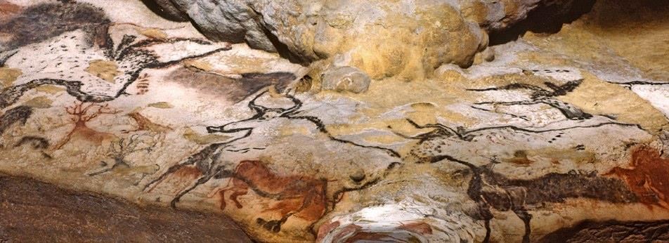
The Cosquer Cave
(cave entrance now 120 feet below sea level)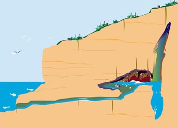
http://www.bradshawfoundation.com/cosquer/photographs/9b.jpg
And some ancient cave art
Sometimes caves collapse, creating karst topography!
Collapsing caves create sinkholes and lakes on the earth's surface.
Karst topography15. What is karst topography?Check out this crazy sinkhole in Guatemala!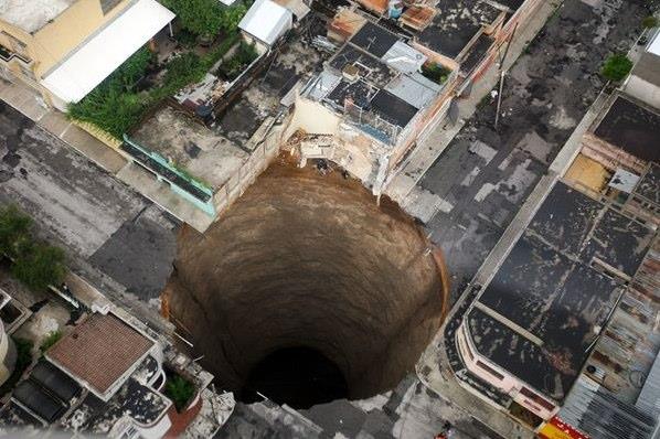
Here is the (hottest) cave!
16. How do caves form?First, to form a cave, you need bedrock made from calcite. Most calcite bedrock is sedimentary in origin.Here is one scenario:
- Tiny sea creatures called cocopods (single-celled algae) live in the ocean. They form a shell (made of calcium) by absorbing calcium from the ocean (just like a clam, lobster, or snail).
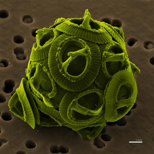
- These small algae die and eventually (after many months) settle to the bottom of the ocean, creating a calcareous ooze.

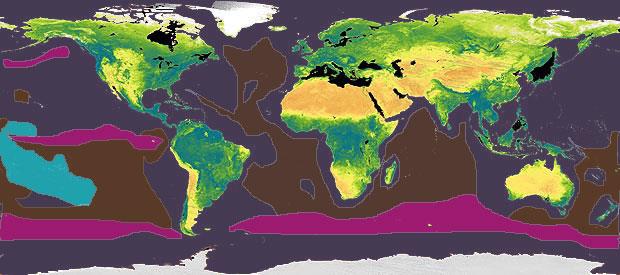
Ocean bottom sediment map. Purple = silicon ooze, brown = calcareous ooze.
http://www.marinebio.net/marinescience/02ocean/mgbottom.htm- After many millions of years, the shells of these tiny creatures accumulate enough to compress the ooze into rock.
- Sometimes, through the process of plate tectonics, these layers get forced onto the continents or uplifted above sea level.
Chalk over 350 feet tall!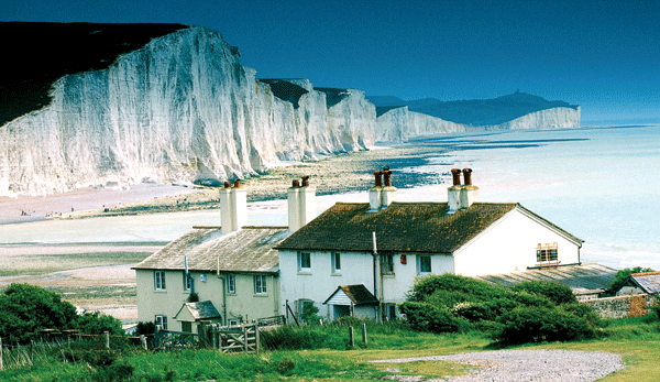
- Once there is a bedrock made from calcite, now nature can begin to form a cave.
- Over millions of years of plants and animals living and dying on the land and rain water-absorbing carbon and soaking into the ground dissolving the bedrock below, giant underground caverns are formed.
17. Acid Rain: Carbon dioxide and Sulfur combine with water in the air to form acid rain.
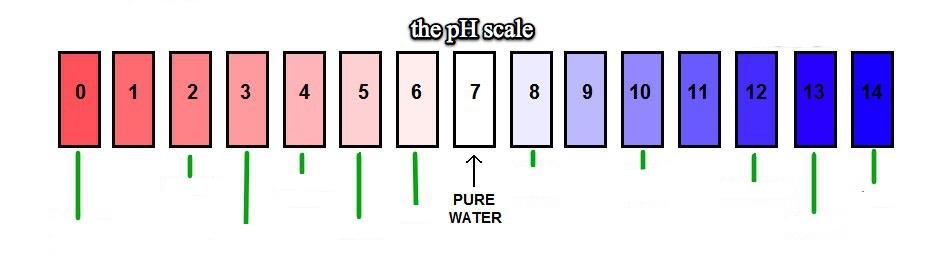 What number do you think is the pH for Vinegar?
Battery Acid?Hand Soap?Milk?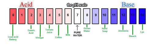
Name two types of rocks that erode faster because of acid rain.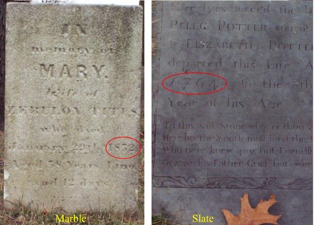
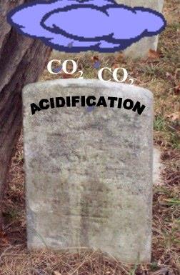
Limestone: made of calcite
Marble: made of calcite
18. Surface Area exposed: When a big rock is broken into smaller rocks, it has more surface area and, therefore, more exposure to weathering. The more weathered the rock is, the faster it weathers.
Broken-up pieces = more surface area = faster weathering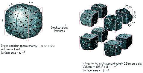
Wind Erosion!
Please write out and answer the questions below in your journal.
18. Can digging a hole in the sand be dangerous?
Why or why not?
Let's make a dune!
19. What is the difference between a pile of sand and a dune?
A dune migrates!
The movement of sediment is called erosion!20. What powers wind erosion?
Remember, wind is part of a convection current that is powered by
The Sun!21. What is an "angle of repose"?
http://en.wikipedia.org/wiki/Angle_of_reposeThe steepest angle at which a material can be piled
without slipping or falling.
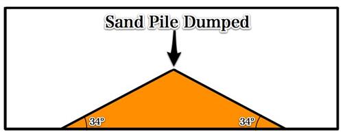
A Pile of Sand
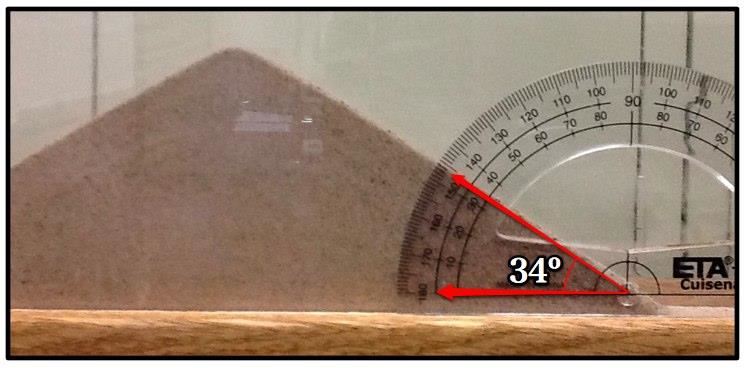
Angle of Repose
Wet loose Sand = 45°
Dry loose Sand = 34°Compacted wet sand can make nice sandcastles with much steeper angles.
Here is what happens when you try to make a dune steeper than its angle of repose.
Playing in the Sahara!
Has anyone ever heard of an Antlion?
The antlion uses the angle of repose to trap its prey!
Without knowing, we could end up building our own sand trap!
What happens to the wet sand once it is exposed to the air?22. Why can digging in the sand be dangerous?
Yes, very dangerous! The angle of repose is higher in wet sand.
As the sand is exposed to the air and dries out, the angle of repose decreases, and the sand ends up burying those who dig too deep."If we expect to live on this planet, we need to know how it works." --Thomas McGuire
Be sure to click on the above link!
Let's move our pile of sand and see what happens
23. What will our pile of sand look like if the wind blows from the left?
Please copy down these definitions.Windward side: facing the prevailing windLeeward side: downwind side
Draw and label your dune.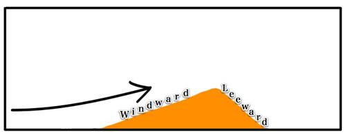
Sand is blown up the windward side of the dune and falls down the leeward side.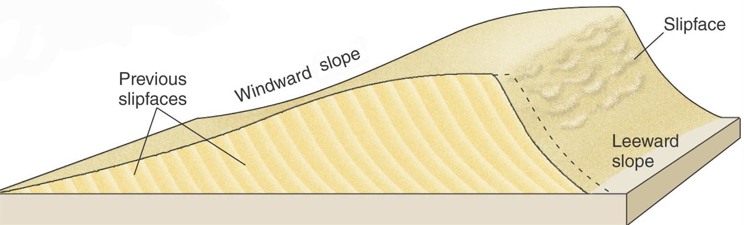 The leeward slope has a slip face at the angle of repose.
23. Draw a dune with the wind blowing from the right.
Label the windward and leeward sides of your dune.
Be sure to have one side steeper than the other.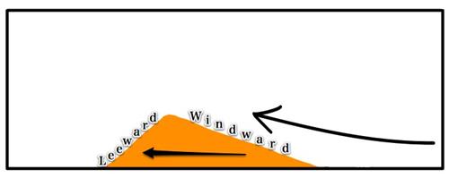 24. Dunes move slowly in the direction of the prevailing wind.
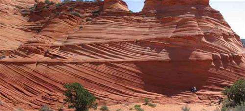 A desert turned to stone!The lines in the sandstone are the ancient slip faces of the leeward side of dunes that moved over the land!
Can you tell which way the wind was blowing in this ancient desert?
Barchan Dunes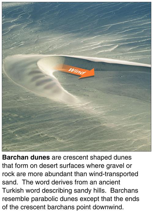 25. Running water is the #1 agent of erosion.Water erosion is powered by the SUN
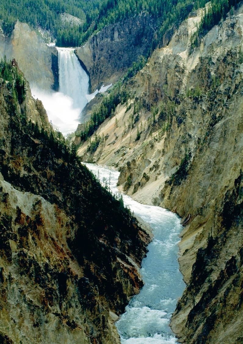
We know that rivers make V-shaped valleys in the mountains, but when the land becomes flatter, rivers end up meandering their way to the sea.
Some rivers erode canyons or gorges and can create waterfalls!
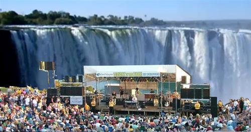
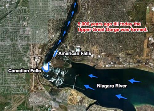
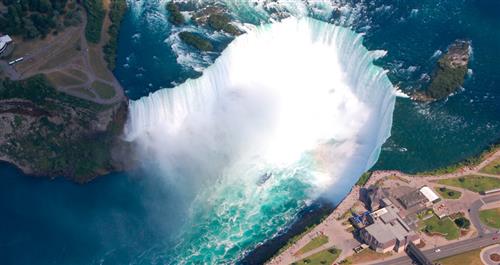 26. Do you think Niagara Falls has always been in the same place?Why or why not?Niagara Falls is constantly moving upstream due to weathering and erosion.
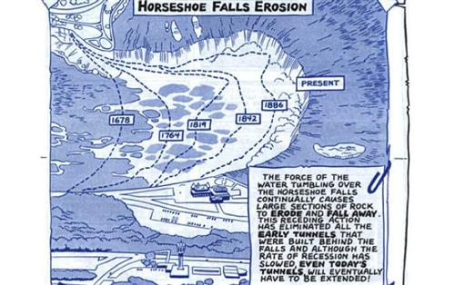 27. Why do waterfalls form?When the top rock layer is harder than layers beneath, the lower layers erode faster and undercut the caprock.This leaves a cliff in the river that water falls over.
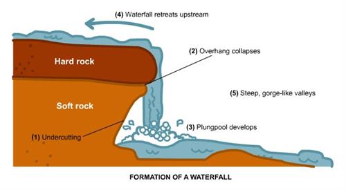
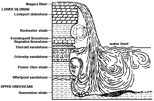 The surface rock (cap rock) is Lockport Dolostone. This cap rock is harder to erode than the Rochester Shale rock layer underneath the Dolostone.
The shale erodes faster than the dolostone, undercutting the cap rock and maintaining the cliff in the river that the water falls over.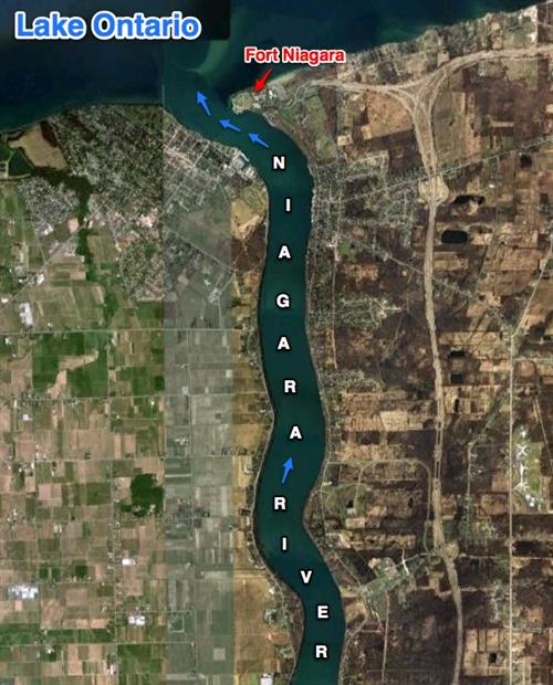
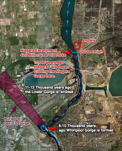
Imagine what Artpark would have looked like 12,000 years ago!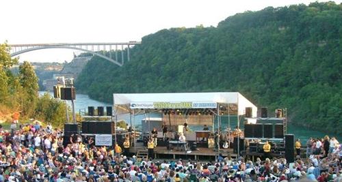
 A little photoshopping can give us a clue.
Flatter land makes rivers slow down, and they start to curve!
Let's make a meander!
28. Meandering Streams: streams that curve or bend
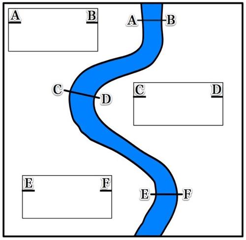
Draw the above in your journals.
29. Where does the water travel the fastest?
Let's see!
Choose your marble!
Like the marbles, water travels fastest on the outside curve of the river meanders.
* Inside Turn - water slows down and deposits sediment* Outside Turn - water speeds up and erodes sediment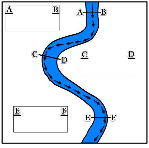
Draw the arrows where the water travels fastest.
Profile A-B
The straight part of the riverDraw the following river cross-sections in your journal.
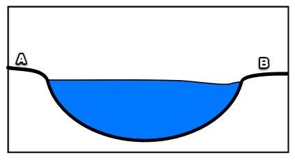
Draw the profile for section A-B.
What do you think C-D will look like?
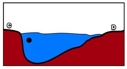
The black dot represents where the water is flowing fastest.
Profile E-F
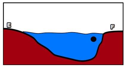
The black dots represent where the water is flowing fastest.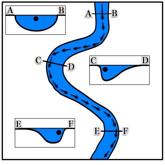
Make sure you have this in your journal.
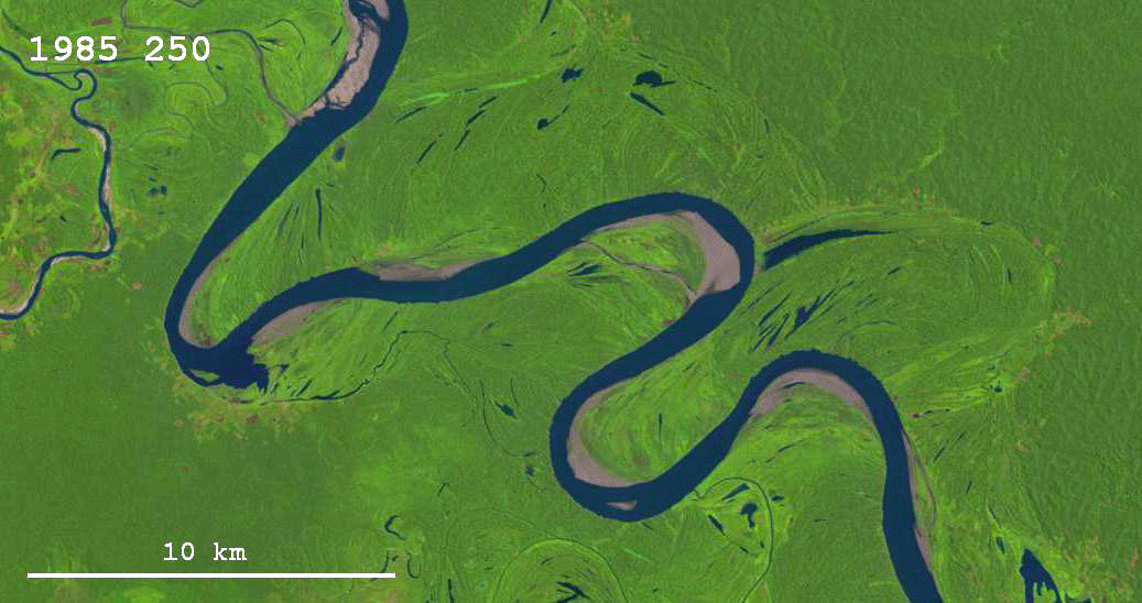
Here is a real meandering river.
Why are some areas light-colored?
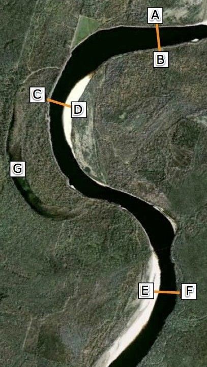
They are sand because deposition occurs on the inside of the meander curve.
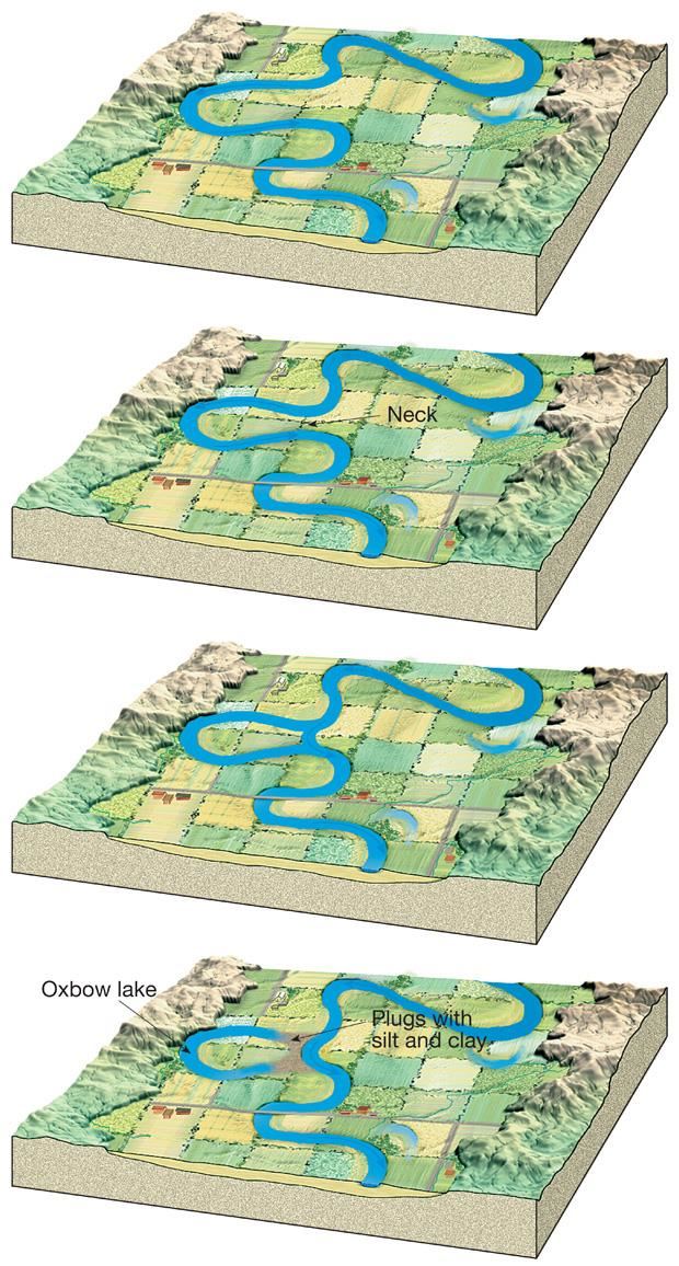
30. What is an Oxbow lake? a cut-off river meander.
What do you notice?
Rivers are nature's conveyor belts taking sediment to the sea.
When rivers meet larger bodies of water, they dump the sediment they carry.
15. What forms at the mouth of a river where sediment is dumped?
River Delta
The Mississippi Watershed!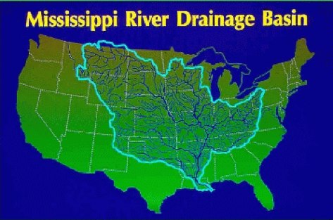 At the mouth of the Mississippi, we find this.Mississippi Delta
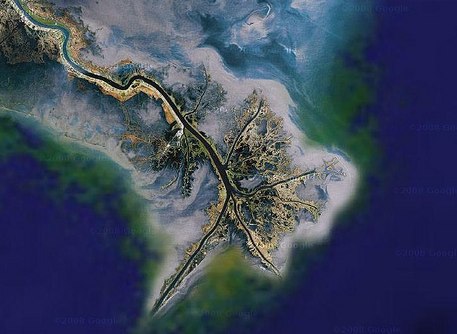 A river-dominated delta
Other deltas around the world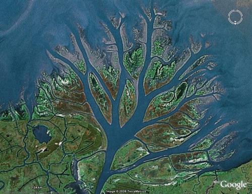 River dominated delta
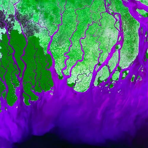 Tide dominated delta
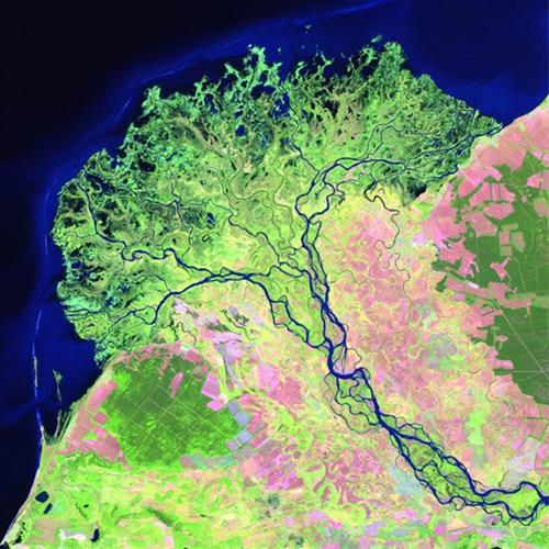 Wave dominated delta
Review Videos
Physical Weathering
Chemical Weathering
Reflection
Explain the difference between weathering, erosion, and deposition
Bonus!Print out and answer the questions below.Reading Extension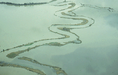
The levee broke!
http://www.scienceclarified.com/landforms/Faults-to-Mountains/Floodplain.html
Floodplains and Levees!
The flooding of a stream or river is a natural and recurring event. Ancient cultures that lived along waterways welcomed the flooding of the land. The material deposited enriched the soil, increasing its fertility for farming. For those along the Nile River in ancient Egypt, the annual flood was the "gift of the Nile." In many modern societies, however, the lands bordering rivers and streams are sites of homes, businesses, and other urban development. The flooding of this land is often a costly natural disaster.
A floodplain is an area of nearly flat land bordering a stream or river that is naturally subject to periodic flooding. A flood occurs when the flow of water in a stream becomes too high for the normal stream channel. In a flood, water flows over the stream's banks, submerging the adjacent land. As water flows out of the stream's channel, it immediately slows down. The material carried by the stream—sediments such as gravel, sand, silt, and clay—is deposited on the floodplain. Large particles are deposited first, and much of this material is laid down alongside riverbanks. This process, repeated over and over, forms ridges or mounds known as natural levees. Natural levees are composed primarily of gravel and sand. They are steep on the side facing the stream and gently sloping on the other side. Levees may be several feet high and up to a mile or more in width.
The finer sediments transported by the floodwater, silt, and clay, are deposited on the floor of the floodplain away from the levees.
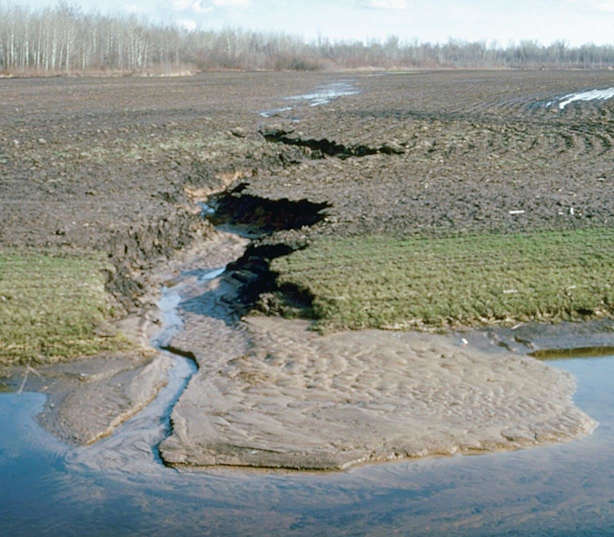
Floodplains are widened as a stream snakes its way across a landscape. Streams and rivers rarely flow in straight lines. Because of this, many stream channels form a series of smooth bends or curves called meanders. As a stream begins to meander, erosion will take place on the outer parts of the bends or curves where the velocity of water is highest. Sediment will be deposited along the inner bends where the velocity is lowest. As erosion and deposition continue, a stream tends to change shape and shift position across its floodplain.
Eventually, a meander forms a tighter and tighter curve until it almost becomes a complete loop. The stream then shortens its course by eroding through the land or neck of the loop. Sediment is deposited, isolating the cutoff meander from the stream. Still filled with water, the crescent-shaped meander is called an oxbow lake (because it resembles the U-shaped collar used by teams of oxen).
1. Describe the process of forming a natural levee.
2. How would you identify an oxbow lake?
3. What are some advantages and disadvantages of building levees?
